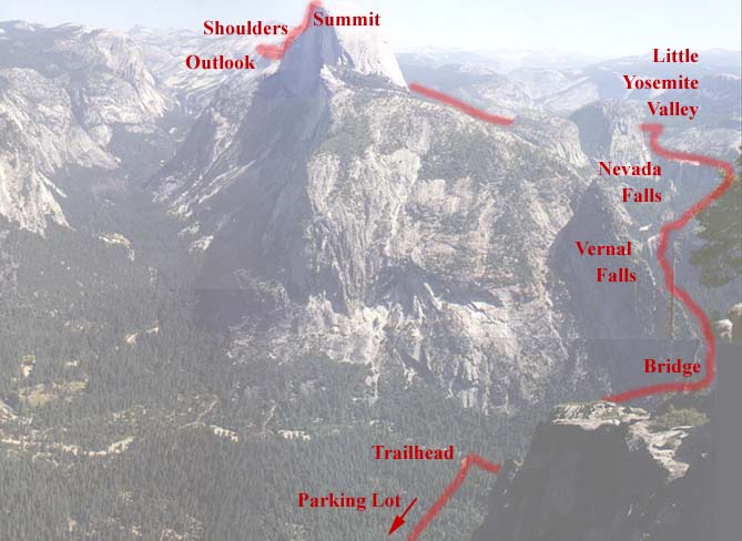


The hike begins at the Happy Isles trailhead, but first you have to hike the 1/2 mile or so in from the overnight parking lot. From there it is about 0.9 miles to the foot bridge at the bottom of vernal falls. This gives you you're first good look at what lies ahead. From there we took the Mist Trail ending in 500 granite steps up Vernal Falls. We decided to depart the Mist Trail and take the easier but longer John Muir Trail up the next falls due to our heavy loads. After a short rest at the top of Nevada Falls, its only a short climb then a nice flat walk in to the backpackers camp at Little Yosemite Valley. A wilderness permit must be obtained to camp here, but in return you get a nice flat spot fairly close to the river, with bear boxes, composting toilets, and a Ranger keeping an eye on things.
Continueing around the back side of Liberty Cap, the ascent up the backside of Half Dome begins. Before the steep climb up to the shoulders there is a nice spot to rest and look out over the valley, and at the climb that lies ahead. The trail up to the shoulders is a very steep network of switchbacks, and narrow granite steps. After a good rest and chance to soak the amazing views, its on to the summit. Cables are anchored into the rock to enable the hikers to make it to the summit. The portion of the topo map below gives a good sense of the difficulty of the route. The close proximity of the contours between the shoulders and the summit shows about a 500' climb in about 500 linear feet. This results in an average angle of 45 degrees, indicating that some portions must be quite a bit steeper than this, since the begining and end are certainly less than 45 degrees. This seems acurate as there are parts of the final climb that are well beyond the point of foot traction, and a fair amount of upper body pull is required. Once at the top, a nearly flat area the size of a football field 1000' above the highest objects around and 5000' above the valley floor presents awe inspiring views of inconcievable scale. Photographs can never do justice to the feeling of standing on top of that dome staring down at the specs of buildings in the valley.
Now that you know the lay of the land, lets get on to the hike photos!

| Check out a closeup of the falls | Lets get to the hike! | Back to the Half Dome homepage |